120K CUT
The itinerary 2025
From San Candido to Tarvisio
Discover the legendary 4 stages of 120k CUT
4 stages totalling 136 km and 6,467 m difference in altitude
1st STAGE
FROM SAN CANDIDO TO VAL VISDENDE
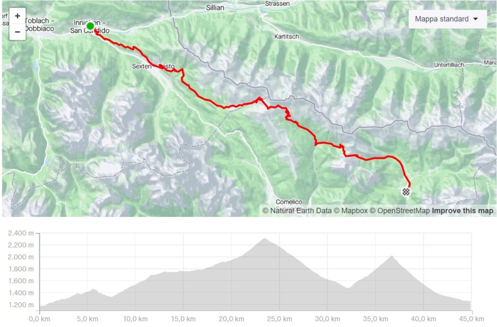
The start is shared with the athletes of the 177K Carnica Ultra Trail for the first few kilometres, then while the 177K route climbs towards Monte Elmo, that of the 120K continues along the woods and meadows above the villages of Sesto and Moso until it touches the Monte Croce Comelico Pass. Passing Malga di Nemes, it climbs to Forcella Silvella below Monte Quaternà, the scene of violent clashes during the First World War. From Forcella Silvella we descend along the forest track to the malga, admiring the wonderful Digon Valley. Further on, turn left and climb up the Val Melin to the cheese factory of the same name, and from here to the Palombino pass, where the view opens out onto the Val Visdende and Monte Peralba. From the pass, descend along the forest track to the valley and from here follow the road to the base camp located at the Da Gasperina hotel.
DISTANCE
45.0 km
ELEVATION GAIN
1.916 m
TYPE OF TRAIL
15% asphalt - 65% forest track - 20% footpath
1st STAGE
FROM SAN CANDIDO TO VAL VISDENDE
The start is shared with the athletes of the 177K Carnica Ultra Trail for the first few kilometres, then while the 177K route climbs towards Monte Elmo, that of the 120K continues along the woods and meadows above the villages of Sesto and Moso until it touches the Monte Croce Comelico Pass. Passing Malga di Nemes, it climbs to Forcella Silvella below Monte Quaternà, the scene of violent clashes during the First World War. From Forcella Silvella we descend along the forest track to the malga, admiring the wonderful Digon Valley. Further on, turn left and climb up the Val Melin to the cheese factory of the same name, and from here to the Palombino pass, where the view opens out onto the Val Visdende and Monte Peralba. From the pass, descend along the forest track to the valley and from here follow the road to the base camp located at the Da Gasperina hotel.
DISTANCE
45.0 km
ELEVATION GAIN
1.916 m
TYPE OF TRAIL
15% asphalt - 65% forest track - 20% footpath
2nd STAGE
FROM VAL VISDENDE TO COLLINA DI FORNI AVOLTRI
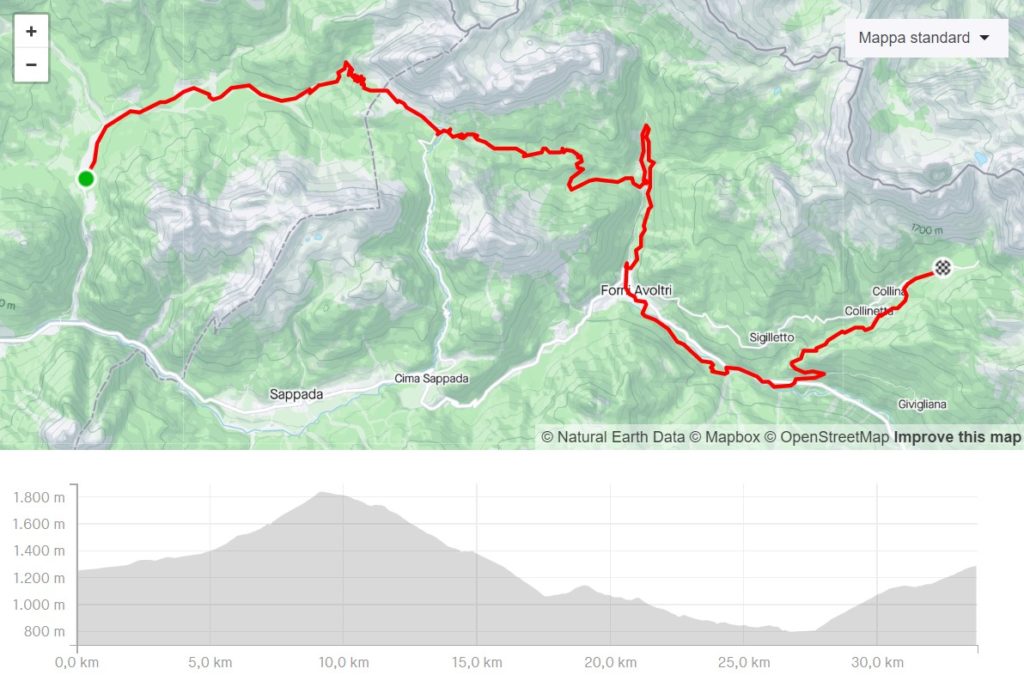
From the base camp, take the road again and climb up towards Monte Peralba, first along a forest track and then along an easy path to the Sorgenti del Piave hut. After passing the springs of the Fiume Caro alla Patria (Caro alla Patria River), continue towards Passo Avanza and from here, along a forest track, descend towards Pierabech and the Fleons valley.
DISTANCE
33.0 km
ELEVATION GAIN
1.275 m
TYPE OF TRAIL
10% asphalt - 80% forest track - 10% footpath
2nd STAGE
FROM VAL VISDENDE TO COLLINA DI FORNI AVOLTRI
From the base camp, take the road again and climb up towards Monte Peralba, first along a forest track and then along an easy path to the Sorgenti del Piave hut. After passing the springs of the Fiume Caro alla Patria (Caro alla Patria River), continue towards Passo Avanza and from here, along a forest track, descend towards Pierabech and the Fleons valley.
DISTANCE
33.0 km
ELEVATION GAIN
1.275 m
TYPE OF TRAIL
10% asphalt - 80% forest track - 10% footpath
3rd STAGE
FROM TROPOLACH TO BAITA WINKEL
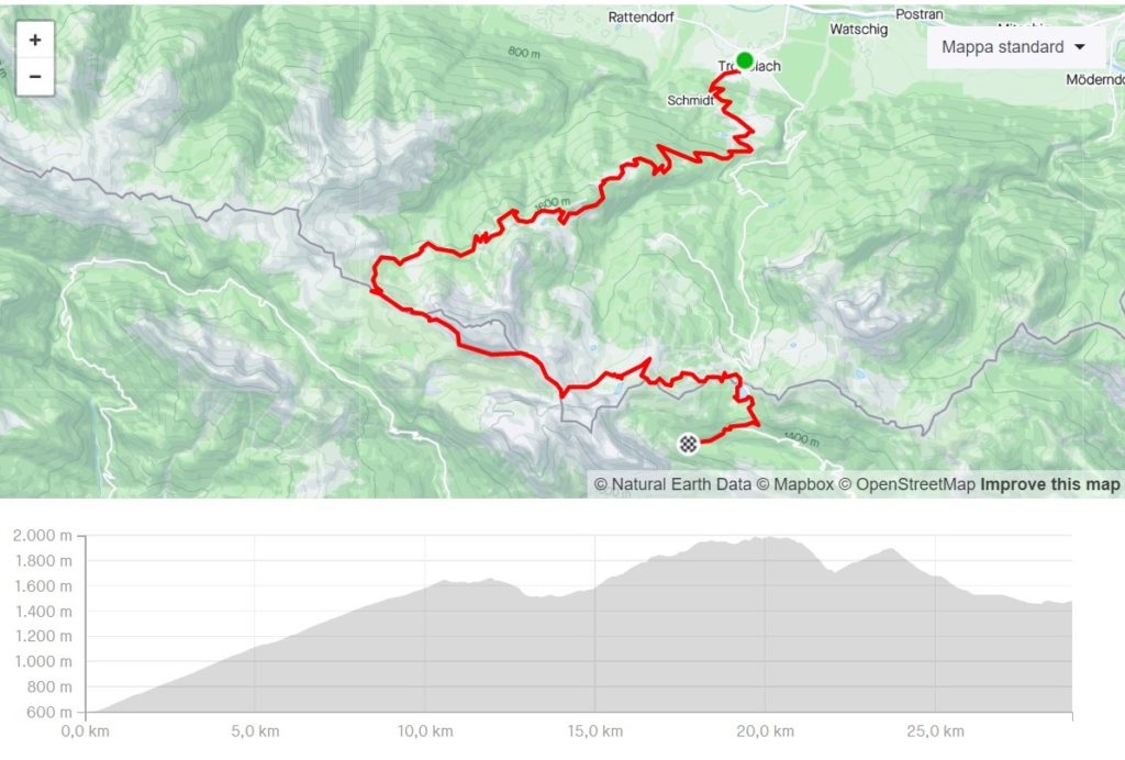
From the base camp in Collina there is a transfer by organisers' vehicles to Tropolach, where the start will be set up. From the village centre, take the road to Tropolacher Alm, which after a few kilometres becomes a comfortable forest track. At the Alm, the route continues in the direction of the Rattendorfer Alm, first on a forest track and then on a footpath. From the alpine hut you then climb up towards Sella di Val Dolce from where you will follow the path 403 shared with the 177K to the base camp of Baita Winkel passing through Sella di Aip in the sight of Creta di Aip and Monte Cavallo di Pontebba. From the saddle, we will continue towards Monte Madrizze and then on to Lake Pramollo and then to base camp.
DISTANCE
29.0 km
ELEVATION GAIN
1.952 m
TYPE OF TRAIL
10% asphalt - 50% forest track - 40% footpath
3rd STAGE
FROM TROPOLACH TO BAITA WINKEL
From the base camp in Collina there is a transfer by organisers' vehicles to Tropolach, where the start will be set up. From the village centre, take the road to Tropolacher Alm, which after a few kilometres becomes a comfortable forest track. At the Alm, the route continues in the direction of the Rattendorfer Alm, first on a forest track and then on a footpath. From the alpine hut you then climb up towards Sella di Val Dolce from where you will follow the path 403 shared with the 177K to the base camp of Baita Winkel passing through Sella di Aip in the sight of Creta di Aip and Monte Cavallo di Pontebba. From the saddle, we will continue towards Monte Madrizze and then on to Lake Pramollo and then to base camp.
DISTANCE
29.0 km
ELEVATION GAIN
1.952 m
TYPE OF TRAIL
10% asphalt - 50% forest track - 40% footpath
4th STAGE
FROM CAMPOROSSO TO TARVISIO
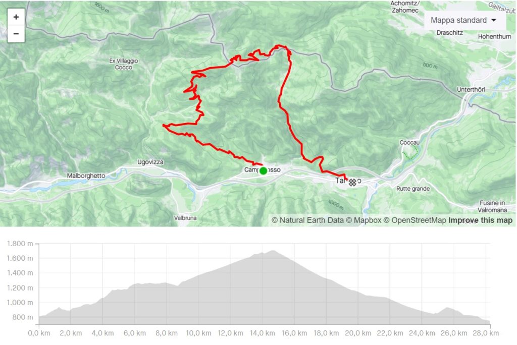
From the base camp of Baita Winkel there is a transfer by organisation vehicles to Camporosso in Valcanale, where the start will be set up. From the village centre, take the forest track that leads to the Agriturismo Gaceman. From here, first take the forest road and then the path to the track that leads to the Acomizza Alpine hut under the mountain of the same name, from where you can feast your eyes on the splendid view of the Julian Alps. From the malga, take the forest track following the CAI 403 signpost, sharing the 177K route again as far as Sella di Bartolo. From the saddle you leave the 177K route and descend towards Val Bartolo until you reach Camporosso again and take the Alpe Adria cycle path that will take you to Tarvisio!
DISTANCE
29.0 km
ELEVATION GAIN
1.189 m
TYPE OF TRAIL
2% asphalt - 90% forest track - 8% footpath
4th STAGE
FROM CAMPOROSSO TO TARVISIO
From the base camp of Baita Winkel there is a transfer by organisation vehicles to Camporosso in Valcanale, where the start will be set up. From the village centre, take the forest track that leads to the Agriturismo Gaceman. From here, first take the forest road and then the path to the track that leads to the Acomizza Alpine hut under the mountain of the same name, from where you can feast your eyes on the splendid view of the Julian Alps. From the malga, take the forest track following the CAI 403 signpost, sharing the 177K route again as far as Sella di Bartolo. From the saddle you leave the 177K route and descend towards Val Bartolo until you reach Camporosso again and take the Alpe Adria cycle path that will take you to Tarvisio!
DISTANCE
29.0 km
ELEVATION GAIN
1.189 m
TYPE OF TRAIL
2% asphalt - 90% forest track - 8% footpath